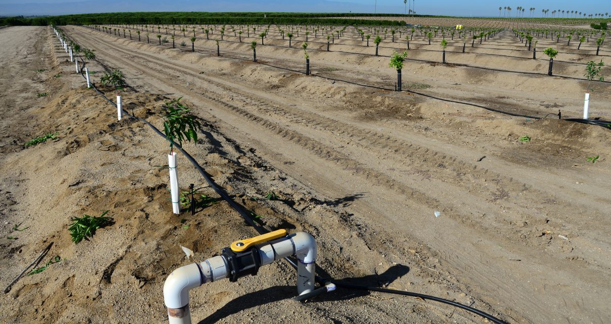
Newly planted almond trees on a San Joaquin Valley farm are watered with a drip irrigation system seeking efficiency in a time of drought in California. (Photo: Richard Thornton/Shutterstock)
Water Blueprint for the San Joaquin Valley
The SJ Valley is less than one percent of the total landmass in the U.S., yet produces 60% of the country’s fruits and nuts and over 30% of its vegetables
By Don Wright, July 21, 2023 11:25 am
The Water Blueprint for the San Joaquin Valley is a non-profit organization formed in 2019 with the goal of bringing together all the interests impacted by surface and groundwater supplies available to the San Joaquin Valley. It’s a coalition of the willing with participation from the agricultural, labor and agency communities. That community includes anyone who eats food.
The Harrison Company’s 100 Mile Circle study shows the Valley is, “. . . less than one percent of the total landmass in the U.S. Yet, it produces 60 percent of the country’s fruits and nuts and over 30 percent of its vegetables.”
SGMA
A Public Policy Institute of California study showed if left unchecked, California’s Sustainable Groundwater Management Act of 2014 (SGMA) could easily cause more than one million acres of the most productive farmland on earth to go out of production. This fallowing of land would ignite a massive economic hardship on not just the farms and farming based communities but the entire region.
There are other states and even nations that have written laws regulating the use of groundwater. Unlike California they studied the problem and arrived at a plan designed to address a solution. SGMA went about it differently; identifying the problem and mandated locals interests form Groundwater Sustainability Agencies (GSA) tasked with writing a Groundwater Sustainability Plan (GSP) that would not so much solve the problem as avoid undesirable results.
Surface Supply
Historically the San Joaquin Valley relied on water supplies provided by nature in the form of melting snowpack in the Sierra Nevada Range being captured in reservoirs. This stored surface supply would be released for irrigation use during the summer and early fall when temperatures often exceed 100 degrees on the Valley floor.
Permanent crops such as orchards and vineyards, and row crops such as tomatoes, onions and cotton were flood irrigated with part of the applied surface water meeting the plant’s evapotranspiration needs and the rest percolating into the underlying aquifer. This is known as conjunctive use. The water stored in the aquifer could then be used by pumping during times of drought. California’s reservoir system was originally designed to provide four to five years of supplies in storage to take both agricultural and urban needs through drought. That was more than 50-years ago when the state’s population was 16,000,000. It’s now somewhere around 40 million people and there hasn’t been any new major statewide infrastructure built since the 1960s.
Two-thirds of the state’s precipitation falls north of the Sacramento/San Joaquin River Delta and two-thirds of the state’s use takes place south of there. There are two main infrastructure projects that move this water from where it falls to where it is needed: the State Water Project and the federal Central Valley Project. The San Joaquin Valley benefits from both. Irrigation and water districts along its length subscribed to the projects, indebting themselves to pay off the capital expenses and contracting for the right to purchase and use the conveyed water.
Prior to 1978 it wasn’t at all unusual for a district’s contract supply to be 100 percent during normal to wet years. Since then there have been a minimum of at least eight major cutbacks in surface deliveries due to legislation and regulatory revisions. This chipping away of surface supplies has dropped the average amount to contract fulfillment to less than 50-percent since 2009. In 2014, for the first time in history, the Friant Division of the CVP received a zero allocation of surface supplies. Then it got socked with zero supplies again in 2015.
This reduction in surface supplies has had an economic impact that has caused a change in cropping patterns and irrigation methods. Many growers have opted for more valuable permanent crops that can be watered by micro-irrigation. Nuts in particular have been an appealing investment, but they have to receive water every year. The option for growers to switch from garlic to melons or cut back on acreage planted in a given year is gone. Also gone is the natural recharge that takes place from flood irrigation and the conjunctive replenishing of aquifer reserves. The return on investment is bigger with permanent crops but so is the time needed to realize the return.
As mentioned, permanent crops must be irrigated regardless of the weather so when dry years hit as they always do in California, pumps turn on. The loss of surface supplies caused the groundwater table to drop from pumping. In areas with clay soils this sometimes cause land to collapse on itself causing subsidence. Something has to be done but a combination of reduced supplies and the onerous impact of SGMA is a loaded gun aimed at the Valley.
Water Blueprint
As an awareness of the dire consequences of massive land fallowing dawned on Valley leaders they came together to form the Blueprint. One of the first tasks the Blueprint commissioned was an economic study of SGMA’s impacts. The Blueprint Economic Impact Analysis: Phase One Results by UC Berkeley economists Drs. David Sunding and David Roland-Holst.
The study is a sobering look at what’s in store if the Valley can’t come together as a region and address its water supply problems. It finds a farm revenue drop of more than $7 billion annually resulting in 42,000 jobs lost along with the loss of $1.1 billion in wages and salaries per year. That will trigger another 85,000 jobs lost and $2.1 billion in employee compensation annually because the farmers and farm workers won’t have money to spend in the communities where they live and used to work. Another 20,000 jobs outside the Valley but related to its ag output could also be lost. Sadly, the greatest amount of economic destruction will take place in the disadvantaged communities in the Valley. The loss of income will place a greater strain on social and government services as tax revenue falls. And there will be higher food prices for the consumer statewide, nationally and internationally.
An Environmentally Friendly Solution
One of the partial solutions the Blueprint is developing is the Environmentally Friendly Diversion project. An average of water years shows 10 million acre feet of water flows out of the Delta, under the Golden Gate and into the Pacific. This is water above and beyond the amount needed for environmental regulations.
The San Joaquin Valley needs an additional two million acre feet of water to prevent the economic waste being imposed by reduced surface water deliveries and SGMA. But it can’t get it because of environmental restrictions. There are two pumping plants located on the southwest part of the Delta; the state Banks Plant and the federal Jones Plant. This is the first step in moving water from north to south. The pumps take in water from the Delta flows and send them down large canals.
The pumps are so powerful they can entrain aquatic wildlife. Unfortunately, some of this wildlife is either threatened or endangered such as smelt and juvenile salmon. A screen was installed to protect the fish. Recall the vast majority of water infrastructure was built more than half a century ago. There are times when the pumps have to be shut down to protect the fish from the screens meant to protect them from the pumps. This situation often comes up during the brief time high flows from snowmelt are passing through the Delta.
The Blueprint’s Technical Committee under the leadership of Dr. Scott Hamilton has found a simple solution to prevent the entraining of flora and fauna – the Environmentally Friendly Diversion. Instead of taking water from the side of the flow column, water would be taken from the bottom. Perforated pipes would be buried under the streambed and water would be transported through them to a reservoir for the pumps to draw from. Because of a slow rate of percolation and the fishes’ natural buoyancy there would be no force exerted on the little fellers, they can just float on by.
This technology has already been proven on other river systems in California. Studies are currently underway at the University of Colorado’s water lab to help fine tune the considerations of gravel pack, pipe spacing and other technical issues to determine the best design.
This additional source of water would be a natural fit for the Valley, where it is estimated there is room to store more than 75 million acre feet underground in aquifers. Southern California water agencies already partner with agencies in the Valley to bank water underground. This additional source could provide water for far more than just farms, as important as that is to be sure.
While a fish friendly diversion isn’t the silver bullet to cure all of the Valley and the state’s water woes – it is a relatively economical and environmentally sound alternative to allowing our food supply and a large portion of the state’s economy to dry up while millions of acre feet of water above all current needs flow out to sea.

- Jottings: California State Assembly Water, Parks & Wildlife Committee 4/29/2025 - April 30, 2025
- State Water Board’s Reckless Handing of the Sustainable Groundwater Management Act - March 4, 2025
- State Water Board Held Hearing Concerning Placing Kern Subbasin Under Probation, Part I - February 25, 2025
What a thorough explanation of the SJ valley’s water problem and a solution…thank you Don Wright! It’s shameful how low of a priority both our state and federal governments give the entire Central Valley’s food production from Bakersfield to Redding. Any other country in the world would be thrilled to be endowed with the miracle of our valley and its Sierra / Cascade range water sources. It’s sickening to see the dozed up tree stumps baking in the dust along I-5 and Hwy 99. And try buying a locally grown tomato in a “Sacratomato” area grocery store…I see the trucks loaded with them but I think I read that they’re processed into tomato sauce and ketchup now. The rice farmers in the Sacramento Valley are reducing their acreage because of water restrictions too. You go to the store and all the produce we used to buy from the valley farms is now sourced from Peru, Argentina, Australia, Mexico and so on. Seriously…California residents having to buy tomatoes grown in a Canadian greenhouse? Makes zero sense but here we are wasting the potential bounty of Twain’s “crown jewel of the new dispensation”