

Bike lane. (Photo: cityofsacramento.gov)
‘DEI Bike Lanes’ – Sacramento City Council Inflates Bicycling Numbers for Federal Taxpayer Grants
Complaint alleges the City of Sacramento used false bike trail-usage figures to win nearly $10 million
By Katy Grimes, October 12, 2026 7:44 am
Recently, Transportation Secretary Sean Duffy announced the end of federal funding for “DEI bike lanes.”
Sacramento didn’t get the memo.
“Sean Duffy, Mr. Trump’s transportation secretary, has argued that when bike lanes cut into space for cars and trucks, the result is more congestion, ‘longer travel times and wasted fuel,'” The New York Times reported. “But Mr. Duffy and his colleagues have also deployed rhetoric that suggests the bicycle is hopelessly lefty, belonging in the same category as green-haired baristas, Rosie O’Donnell and yard signs professing that love is love.”
Remember when Biden and Boot-edge-edge used YOUR MONEY for DEI bike lanes and climate change? THAT’S OVER I just redirected $1.73 billion in USDOT grants away from Biden-era DEI pet projects Now this funding is officially locked in to fix America’s actual backbone: ROADS, BRIDGES, AND SHIPPING PORTS @realDailyWire ➡️ https://t.co/3EcWwywyFp
— Secretary Sean Duffy (@SecDuffy) July 7, 2026
At issue in Sacramento, California is construction of an approximately 3.8-mile levee-top multi-use trail for bicycle and pedestrian recreational use and commuter travel between Garcia Bend Park and Zacharias Park in Sacramento’s Pocket neighborhood. The project will include neighborhood access ramps and pedestrian crossing improvements. The Sacramento City Council approved the preliminary design plan and adopted the Addendum to the 1997 EIR on October 14, 2025.
The Sacramento City Council appears to have boosted the numbers of bicycle riders from the 32-mile American River Parkway and applied them to the more obscure 3.8 mile bike trail atop the levy on the Sacramento River, to land millions in federal transportation funds – funds that are supposed to be used for reducing traffic congestion.
A Sacramento resident recently filed a complaint with the US Department of Transportation Office of Inspector General, alleging that the City of Sacramento used false bike trail-usage figures to win nearly $10 million in competitive federal grants for the Sacramento River Parkway trail project.
The Transportation OIG has reviewed the complaint and referred it to the Federal Highway Administration for review.
The Sacramento River Parkway’s grants fall squarely within Secretary Duffy’s “DEI bike lanes” review window, specifically targeting projects that touted “equity” benefits. Sacramento’s applications explicitly invoked Environmental Justice community status to score competitive points, and its funds are not yet fully obligated.
At the core of Sacramento’s “DEI bike lane” project is the city’s projection that the Sacramento River Parkway Bike Trail would have as many users as the region’s American River Parkway – a 32-mile parkway that has beaches, recreational amenities, equestrian trails, and a nature center. It’s a ridiculous and fraudulent comparison. Those numbers presumably helped the city receive millions in competitive grants, while other more deserving projects in the region that would actually reduce congestion received nothing.
The City claims 9,000 average daily trips on the 3.8 mile bike trail, will translate into 15,006 annual auto trips reduced, and 56,871 annual auto Vehicle Miles Traveled reduced.
This is preposterous. Sacramento’s Pocket neighborhood has about 27,000 residents.
From the federal complaint:
THE PATTERN ACROSS BOTH ROUNDS
The misconduct described in this complaint is not an isolated error. It is a documented pattern across two successive competitive grant rounds:
In 2021, the City submitted 13,500 — 100% of the American River Parkway’s daily usage equivalent — as the Average Daily Trips/Traffic (ADT) for a 4.0-mile residential levee trail that terminates before the downtown connection is complete, with the ADT field left blank at zero in the simultaneously submitted PPA tool. The City received $3,120,000.
In 2022/23, the City submitted 9,000 — 67% of the American River Parkway’s daily usage equivalent — implemented by inserting “2/3” into the prior year’s otherwise identical note, with no new study, no new model, and no new analysis. The same application submitted 9,619 in the CMAQ calculation — a different, higher, internally inconsistent figure within the same package. The City received a staff-recommended award of approximately $6,803,000.
In neither round did the City cite a trail demand study, demand model, comparable facility analysis with supporting data, or any other documented basis for the specific Average Daily Trips figure or percentage used. In neither round did the City’s cost-effectiveness ADT figure bear any traceable analytical relationship to the observed transportation characteristics documented in its own required PPA materials. In neither round did SACOG’s program review cross-check the cost-effectiveness ADT figure against the PPA data submitted in the same application package — a systemic gap this complaint asks the OIG to address through program-level recommendations.
Moreover, the harm from the false Average Daily Trips representations extends beyond the federal funds directly awarded to the City of Sacramento. The SACOG Regional Program Transformative Category operates as a competitive zero-sum program with a fixed federal funding pool each cycle. Every dollar awarded to the Sacramento River Parkway Project based on artificially elevated cost-effectiveness scores was a dollar unavailable to other projects competing in the same round.
Federal Funding Source: Congestion Mitigation and Air Quality (CMAQ) and Regional Surface Transportation Program (RSTP) funds administered by the Sacramento Area Council of Governments (SACOG) as the designated Metropolitan Planning Organization
Known Federal Awards (Prior Rounds):
- 2020/2021 SACOG Regional Program round: $3,120,000
- 2022/23 SACOG Regional Program round: approximately $6,803,000 (staff-recommended award)
- Combined total awarded to date: approximately $9,923,000
Currently Programmed Metropolitan Transportation Improvement Program (MTIP) (2025 FSTIP):
- SAC25264 (Phase 1): $11,644,000 total; $7,954,000 federal; construction target 2027
- SAC25265 (Phase 2): $4,059,128 total; $850,000 federal; construction target 2028
- Combined MTIP total: $15,703,128; federal portion: $8,804,000
- FY2025/26 federal funds at immediate risk of obligation: $1,995,000
The City took the American River Parkway’s total annual system-wide visitation and simply applied it as the projected daily usage for this specific 4.0-mile project segment.
The Sponsor’s Note expressly conditions the 13,500 Average Daily Trips on completion of the ultimate Sacramento River Parkway trail to downtown. Notably, This project does not complete the trail to downtown, as it terminates at Zacharias Park. North of Zacharias Park, a 1.4-mile fenced-off gap through the Little Pocket neighborhood remains, and it is acknowledged in the City’s own 2022/23 application as a separate future project with no funding, no timeline, and no commitment. The City submitted an ADT projection conditioned on a network that this project does not produce and cannot produce alone.
This application resulted in a federal award of $3,120,000.
Document 2 — 2022/23 Application, Application Element 5: Cost-Effectiveness Calculation, and Application Narrative
(Attached as Exhibits B & B.1)
Approximately one year later, the City submitted a second Transformative Category application to SACOG for the identical project (SAC25264, SAC25265), same geographic scope, same project contact, same trail between Garcia Bend Park and Zacharias Park. The cost-effectiveness spreadsheet contains:
- Daily Travel (Average Daily Trips): 9,000
- Annualization Factor: 365
- Project Cost: $20,761,000
- Useful Life: 50 years
- Calculated Score: 7.91 (approximately 8)
The total population of Sacramento’s Pocket area is 25,000.
The Sponsor’s Note reads:
“The Jedediah Smith Memorial Trail along the American River is used by approximately 5M people per year. The ADT assumes 2/3 similar annual usage upon the completion of the ultimate Sacramento River Parkway trail to downtown.”
The two Sponsor’s Notes are word for word identical except for the insertion of “2/3” in the second application. The arithmetic confirms: 5,000,000 × (2/3) ÷ 365 = 9,132, rounded to 9,000.
The entire change in methodology between the 2021 and 2022/23 applications consisted of inserting the characters “2/3” into an otherwise identical sentence.
This application resulted in a staff-recommended award of approximately $6,803,000.
Document 3 — 2022/23 Application, Application Element 6: CMAQ Calculation
(Attached as Exhibit C)
The same 2022/23 application package also includes a CMAQ emission reduction calculation — Application Element 6 — which contains a third distinct ADT figure across the two application rounds:
- Average Daily Traffic (ADT): 9,619 trips per day
- Days of use per year: 325
- Annual auto trips reduced: 15,006
- Annual auto VMT reduced: 56,871
- CMAQ funding requested: $15,237,000
- Project scope described as: 3.79 miles of new Class 1 facility
This figure differs from the 9,000 ADT in the cost-effectiveness calculation submitted in the same application package. The City submitted two different ADT figures within the same grant application with no explanation of the discrepancy and no reconciliation between them.
The The Community Multiscale Air Quality (CMAQ) figure of 9,619 is higher than the cost-effectiveness ADT of 9,000, meaning the CMAQ calculation claims more vehicle-substituting trips than the cost-effectiveness calculation claims total daily users. This internal inconsistency within the same application confirms that no unified methodology generated these figures.
The absolute magnitude of the CMAQ-claimed emission benefits warrants specific attention. The CMAQ calculation claims 15,006 annual auto trips reduced — which at 325 days of use per year represents approximately 46 daily vehicle trips eliminated from a corridor carrying 32,222 single-occupant vehicle trips per day as observed in the 2020 PPA. The project’s entire CMAQ-qualifying benefit is a claimed reduction of less than one-tenth of one percent of existing corridor vehicle traffic. The claimed annual NOx reduction of 11 pounds per year – which is the equivalent to removing approximately 11 passenger vehicles from the road – is the basis on which $15,237,000 in CMAQ-designated federal funds was requested.
CMAQ funds are specifically designated for cost-effective air quality improvements in nonattainment areas. Whether a project claiming 46 daily vehicle trip reductions genuinely qualifies for CMAQ designation is a question the OIG may wish to examine.
In the same 2021 competitive round where Sacramento’s trail received $3,120,000 in CMAQ-designated funds based on an ADT of 13,500, the City of Folsom submitted a documented application for the US 50 Empire Ranch Road interchange and scored approximately 16 on cost-effectiveness — higher than Sacramento’s approximately 15 — and received zero from the same competitive pool. That project would construct a four-lane overpass with full ramp connections on US 50, specifically designed to reduce congestion, improve safety, and reduce travel time for tens of thousands of daily commuters on one of California’s most traveled freeway corridors.
THE AMERICAN RIVER PARKWAY COMPARISON IS INDEFENSIBLE
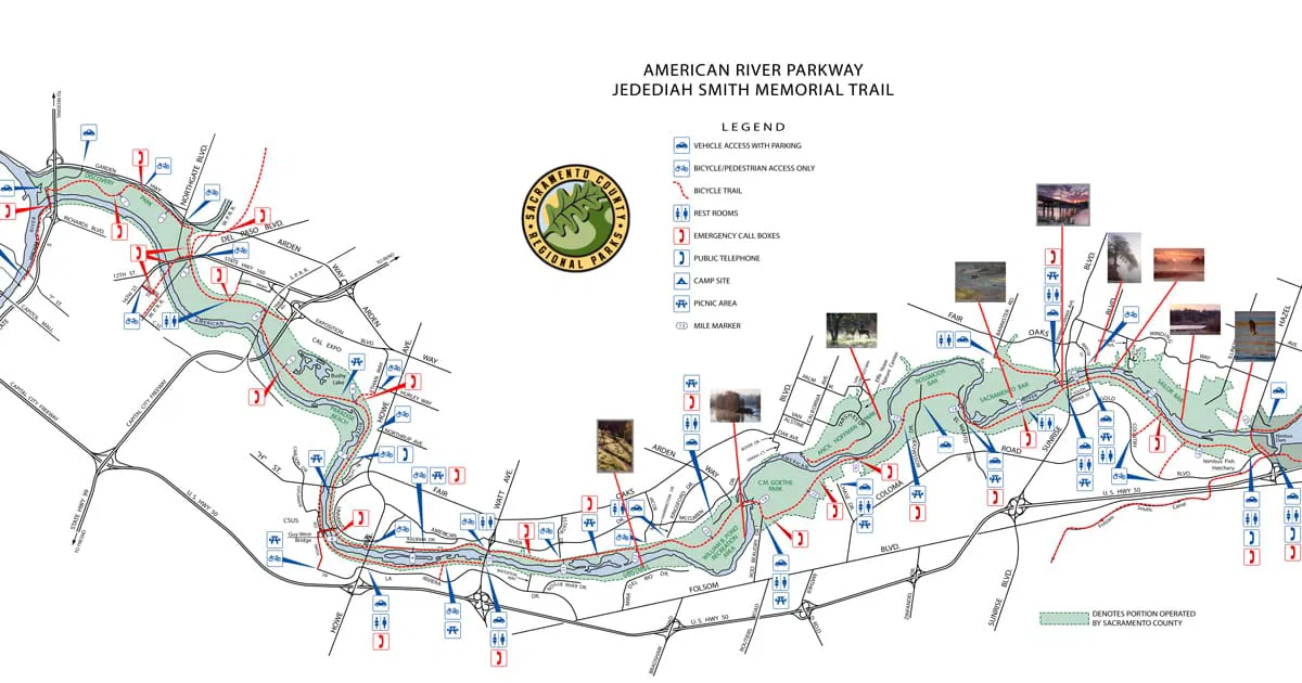
The Jedediah Smith Memorial Trail along the American River (the sole analytical basis for both ADT figures in both applications) is not a valid comparable facility for the Sacramento River Parkway Pocket segment. The relevant differences are objective facts documented in the City’s own application materials.
The network completion condition stated in both Sponsor’s Notes is not satisfied by this project, as acknowledged in the City’s own application. Both notes state the ADT assumes usage upon completion of the ultimate Sacramento River Parkway trail to downtown. The City’s own 2022/23 application narrative acknowledges on page 15 that a separate 1.4-mile gap remains as a future project. This gap is geographically distinct from and north of the current project, which terminates at Zacharias Park. Users attempting to commute from the Pocket segment to downtown must leave the levee at Zacharias Park and navigate surface streets before reconnecting to any existing off-street trail heading toward downtown. The American River Parkway, whose 5 million annual users form the basis of both ADT projections, is a continuous 32-mile off-street system with no equivalent surface-street gap requiring navigation at any point in a user’s journey.
Length. The American River Parkway trail system is approximately 32 miles long. The Pocket segment is approximately 4.0 miles — roughly 12% of the comparison facility’s length. Claiming equivalent total daily usage means the Pocket segment would be used approximately eight times more intensely per mile than the American River Parkway. No analysis supporting this per-mile intensity claim appears anywhere in the application record.
Destination amenities. The American River Parkway has swimming beaches, equestrian trails, fishing access, multiple regional parks, picnic areas, a nature center, and connections to Folsom Lake. These destination amenities generate a substantial portion of the American River Parkway’s 5 million annual users. The Pocket levee trail project is a paved path atop a flood control levee running through residential backyards – at least 68 of which would need to be obtained by the City.
Observed demand characteristics. The City’s own PPA data shows 2% bicycle mode share within 0.5 miles of the project and 814 jobs within walking distance. The City cited both figures in its own application narrative, acknowledging they reflect a highly car-dependent neighborhood with limited active transportation demand. The City derives 13,500 and 9,000 not from this baseline through any documented induced demand methodology, but from the American River Parkway comparison with no adjustment for the fundamental differences between the two facilities.
The arbitrary percentage reduction. The reduction from 100% to 67% of the American River Parkway’s usage between the 2021 and 2022/23 applications was implemented by inserting “2/3” into an otherwise identical note. No analysis explains why two thirds rather than one half or any other fraction. The American River Parkway did not change between 2021 and 2022/23. The project scope did not change. The Little Pocket gap did not close. The network completion condition was no closer to being satisfied. No documented factor changed that would analytically produce a 33% reduction in projected usage. A genuine comparable facility analysis produces a percentage based on documented, cited factors. No such documentation exists anywhere in either application.
Additionally, the complaint notes:
-
A sitting Sacramento City Council member, who also sits on the regional board that awarded the funds, is quoted in the City’s own project meeting minutes as having “worked closely with” that agency to obtain the funding.
-
A CEQA lawsuit has been filed in Sacramento Superior Court challenging the 13,500 number.
-
The federal money is to be used to acquire private property from roughly 70 homeowners, and the City is actively fighting to block those homeowners from even replacing fences that have protected their properties for over 30 years. When the fences were removed for Army Corps levee work, homeowners experienced trespassing, vandalism, and people on their private property at all hours. The City wants to tear down their only private property protection for a DEI trail that has no gates, no monitoring, and no lights.
The Globe will follow up and report on the progression of the complaint, and the 3.8 mile “DEI bike lane.”


A California native and Navy mom, Katy lives in Sacramento, CA.
- ‘DEI Bike Lanes’ – Sacramento City Council Inflates Bicycling Numbers for Federal Taxpayer Grants - October 12, 2026
- American Academy of Pediatrics Doubles Down on Infant/Child Covid Vaccine - October 10, 2026
- Sacramento’s Own Radical Congressional Candidate has Upcoming Event Hasan Piker - October 9, 2026
RELATED ARTICLES
-
 November 28, 2018
 -
October 4, 2018
-
 October 29, 2020