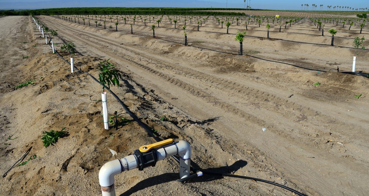
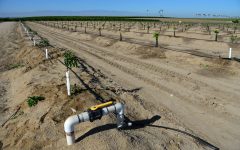
Newly planted almond trees on a San Joaquin Valley farm are watered with a drip irrigation system seeking efficiency in a time of drought in California. (Photo: Richard Thornton/Shutterstock)
State Water Board Report Updates to Bay/Delta Plan Shows Bias Against San Joaquin Valley
How will further limiting transfer water supplies help mitigate limited transfer water supplies?
By Don Wright, February 8, 2024 2:45 am
Proposals contained in a draft report prepared by the State Water Resources Control Board staff recommending updates to the Bay/Delta Plan have triggered warnings of extensive harm due to bias against the San Joaquin Valley and its people.
The draft report can be a tough read with just the title and the table of contents taking up 72 pages. That’s partially why it was released last year in September with a comment deadline of January 2024. It takes a while to get through.
The report is titled “DRAFT Staff Report/Substitute Environmental Document in Support of Potential Updates to the Water Quality Control Plan for the San Francisco Bay/Sacramento-San Joaquin Delta Estuary for the Sacramento River and its Tributaries, Delta Eastside Tributaries, and Delta.”
The duties of the State Water Resources Control Board (State Board) includes, as stated in the draft report, “. . . updating the Water Quality Control Plan for the San Francisco Bay/Sacramento-San Joaquin Delta Estuary (Bay-Delta Plan or Plan) to protect beneficial uses of water in the San Francisco Bay/Sacramento-San Joaquin Delta (Bay-Delta) watershed related to water diversions and operations. The Bay-Delta Plan identifies beneficial uses of water to be protected in the Bay-Delta watershed; narrative and numeric, including flow and salinity, water quality objectives for the reasonable protection of those beneficial uses; a program of implementation to achieve the objectives; and monitoring, evaluation, and special study provisions to evaluate and inform planning and implementation.”
The Water Blueprint for the San Joaquin Valley is a coalition of San Joaquin Valley community leaders, businesses, water agencies, local governments, and agricultural representatives working together to advance common sense water solutions and to improve socioeconomic health for the Valley’s residents.
The Blueprint is the correct entity to evaluate and comment on proposed regulatory and often legislative offerings from the state government to help ensure the Valley isn’t treated like some red headed stepchild, third world, Appalachian afterthought. Something that happens far too often in Sacramento.
The Blueprint reviewed the draft report and came to some startling conclusions in a comment response recently submitted. For one, the report underestimates the amount of water available to the Valley by 300,000 acre feet.
The State Board is limited in its response to regulating flows through the Delta. It can turn water on and off. The more water it directs through the Delta, the less water is available for use in other areas of the state. This is known as the Unimpaired Flow Objectives. State Board staff wants more water flowing out to sea. This additional UFO, whoops sorry it’s referred to as UIF in the report, comes from tributaries along the San Joaquin River – the Merced, Tuolumne and Stanislaus Rivers.
The UIFs are cited by the Blueprint as of particular concern, “Although the Draft Staff Report contains significant information on hydrology, water supply, and agricultural resources, it presents that information in a disjointed manner and is based on inaccurate or inconsistent assumptions.”
It goes on to state, “. . . adoption of the UIF alternative is inconsistent with other statewide policy objectives advanced by the Newsom Administration, including the human right to water, advancement of the coequal goals, and implementation of the Water Resilience Portfolio and Water Supply Strategy.”
An analysis of surface water supplies included in the draft staff report was called out as inaccurate as it was based on Delta operations from biological opinions from 2008 and 2009. This analysis is called inaccurate because the description of existing water supplies didn’t take into account the modifications imposed on the Central Valley Project and the State Water Project by the more recent 2019 biological opinion.
Proposed water supply reductions to the Valley through the CVP and SWP were significantly underestimated in the draft staff report based on an erroneous assumption based on the 2020 Incidental Take Permit’s I:E export limit. This I:E is an inflow-to-export ratio that limits surface supplies available to the Valley.
The Blueprint response, “The magnitude of this underestimation is significant; in some below normal and above normal years, it could be as much as 300,000 acre-feet. For south-of-Delta Central Valley Project agricultural contractors, this represents a potential 10-15% reduction in their contract allocation.”
The Blueprint response had in its footnotes that the staff draft report didn’t uniformly set the limits, including the CVP but not others and potential socioeconomic impacts were “likely significantly underrepresented.”
Impacts on Agriculture
The draft staff report included a chapter “Agriculture and Forest Resources” which describes potential impacts from the UIFs to prime, unique and farmland of statewide importance. It states, “. . . reduced water availability decreases agriculture’s profitability by increasing the price of water, reducing the land’s productivity, or both, the economic incentive to convert to urban use could grow.”
The report got that right, and wrong. In 2015, a dry year 522,000 acres were fallowed in the San Joaquin Valley due to inadequate water supplies compared to 2011, a wet year. UIFs will exacerbate an already dire situation.
The Blueprint states the draft staff report, “. . . fails to appropriately characterize the disparate impact of reductions in Sacramento/Delta surface water supply to differing regions of the San Joaquin Valley.”
The staff draft report states, “While the reductions in Sacramento/Delta surface water supply represent a substantial amount of water, when compared with the total San Joaquin Valley region average annual supply of over 18.4 MAF as estimated by historical water deliveries data, the reductions are proportionally smaller. The reductions in total supply amount to 1 percent and 2 percent in the 45 and 55 scenarios, respectively (see Table 6.4-1).”
The Blueprint points out the most vulnerable areas for urbanization are being placed at greatest risk due to the reduction in surface supplies impacting the CVP and SWP along the Valley’s westside. The area served by the northern portion of Delta Mendota Canal is particularly ripe for equity refugees from the San Francisco Bay Area.
Mitigation Measures
The draft staff report lists measures that might mitigate the reduced water supplies from UIFs. It suggests diversifying the water portfolio with sustainable conjunctive use of ground and surface water, recycling, conservation, efficiency upgrades and water transfers.
The Blueprint response voiced some doubts. It said large parts of the San Joaquin Valley is unlikely to benefit from the actions described. Mostly, if not entirely because sustainable conjunctive use depends on surface water supplies. During wet years irrigation and recharge of surface water is the only way to provide sustainable groundwater for the dry years when pumping is necessary. The reduced water transfers from the Delta to the CVP and SWP will prevent recharge. Increased efficiency also reduces recharge. Micro irrigation supplies water to the crops’ root zones and doesn’t oversaturate applications to the point of recharge benefits.
The Blueprint gives an example – 2015-16 water year for the Northern Sierra precipitation index was 57.9, well above average. Yet the South of Delta allocation for CVP agricultural water contractors was five percent while the SWP allocation was 60 percent. In 2019 the index was 70.7 making it the third wettest year on record. Both the CVP and SWP only received a 75 percent allocation.
The Blueprint response, “Sound principles of conjunctive use demand that in water years like 2016 and 2019, farmers in the San Joaquin Valley rely on surface water and that surplus water be used to replenish groundwater aquifers. However, existing regulations of the Central Valley Project and State Water Project and limited water storage infrastructure already frustrate the implementation of “sustainable conjunctive use,” and each of the unimpaired flow alternatives evaluated by the Draft Staff Report will only further diminish the water delivery capability of the projects in every water year type.” Also asked, “. . . from where will the water to be transferred come and how will it be conveyed to areas in the San Joaquin Valley seeking to offset reductions in surface water?”
The Blueprint response points out the main source of water for transfers in the San Joaquin Valley comes from the Sacramento Valley. Getting that water through the Delta is already a major challenge that will only be exacerbated by the UIFs.
Three problems are pointed out; the transfer window is only open from July 1st through November 30th. Capacity at the CVP and SWP pumping plants is often limited. And biological opinions for long-term CVP and SWP operations limit Sacramento River transfer water pumping to 360,000 acre feet during below normal, normal and wet years. The very types of years when the Sacramento water is available.
The Blueprint is also concerned the UIFs will further limit CVP and SWP operations. The draft staff report doesn’t really address how transfers could play any meaningful role, “It is difficult to predict with certainty how reduced Sacramento/Delta surface water supplies will affect water transfers. With new instream flow and cold water habitat requirements, overall supplies of water from the Sacramento/Delta will decline. This may result in less water available for transfer. At the same time, it could incentivize transfers as the value of transfer water increases, leading to transfers from lower value temporary crops to higher value municipal uses and permanent crops.”
It’s a conundrum, how will further limiting transfer supplies help mitigate limited transfer supplies? The Blueprint response, “. . . it is not difficult to predict with certainty how reduced Sacramento/Delta surface water supplies will affect water transfers to areas in the San Joaquin Valley presently benefiting from transfers. New instream flow and cold water habitat requirements that result in Sacramento/Delta surface water supply reductions in the Sacramento River watershed of the magnitude reflected in Table 6.4-2, (Draft Staff Report, pg. 6-57), will result in a significant decrease in water transfers to south-of-Delta areas served by Sacramento/Delta surface water.”
Water conservation is another method listed in the draft staff report. The San Joaquin Valley’s largest water district, Westlands is already at a 96 percent water use efficiency. And most of the Valley isn’t far behind. At a certain point the law of diminishing returns kicks in. It’s doubtful the expense of capital and effort of additional measures to increase efficiency another four percent will yield any realistic benefit. The reduction in recharge would be an unintended consequence.
On that note the Blueprint states, “Importantly, the Draft Staff Report is confusing because it suggests that increased reliance on groundwater pumping may offset surface water supply reductions, but it then goes on to note that the implementation of the Sustainable Groundwater Management Act (“SGMA”) may restrict the use of groundwater to offset these reductions. (Draft Staff Report, pgs.6-80 – 6-81.) Herein lies one of the biggest challenges in the analysis contained within the Draft Staff Report; it fails to sufficiently evaluate the effects of simultaneously implementing the proposed unimpaired flow objectives and implementing SGMA.”
SGMA Impacts
The Sustainable Groundwater Management Act by itself will bring significant socioeconomic and environmental impacts to the San Joaquin Valley. In February, 2020 a study by Drs. David Sunding and David Roland-Holst, UC Berkeley entitled “Blueprint Economic Impact Analysis: Phase One Results” paints a grim picture of increased land fallowing and retirement resulting in reduce crop production, job losses and economic disruption to the San Joaquin Valley. The Blueprint states enacting the recommendations of the draft staff report will exacerbate the project removal from production of one million acres or more of farmland and 42,000 jobs in the Valley with economic losses exceeding $7.2 billion annually.
An additional 2022 study by Dr. Michael Shires, Pepperdine University entitled, “The Economic Impact of the Westlands Water District on the Local and Regional Economy: 2022 Update,” states, “Perhaps even more importantly, the overall trend of these poverty levels moves concurrently with the reductions in water deliveries from the CVP to the Westlands Water District.”
The draft staff report acknowledges under the Porter-Cologne Water Quality Control Act the State Board is required to consider economic impacts. The draft staff report includes a cumulative impact analysis but it finds the impacts of implementing SGMA are “speculative.”
Air Quality Impacts
The Blueprint response claims the draft staff report mischaracterizes the public health impacts on Valley residents. Implementing the UIFs, diminishing the surface water supplies and fallowing land will create significant exposure to fugitive dust. This dust can be hazardous.
The draft staff report states, “Naturally occurring asbestos and Valley fever are endemic to areas within the study area (i.e., mountain counties and the Central Valley, respectively). The potential for exposure to Valley fever exists in agricultural areas, such as the southern portions of the San Joaquin Valley, where reported Valley fever cases have historically exceeded 10 per 100,000 people (CDPH 2016). Fallowed land could result in exposed soils and windblown fugitive dust, which could increase the likelihood of exposure to naturally occurring asbestos and Valley fever.”
Yet the draft staff report also maintains, “This impact would be less than significant.”
The Blueprint addresses this, “They [State Board staff] have not observed that fallowing fields results in a reduction of windblown dust. The anecdotal observations of people who live and work in the San Joaquin Valley are consistent with a recent analysis conducted by Elizabeth Ann Weaver at Virginia Polytechnic Institute and State University. In her doctoral thesis, Ms. Weaver found climate and land cover variables explain up to 76% of valley fever variability in Kern County. (Investigating the Valley Fever – Environment Relationship in the Western U.S, 2019, Virginia Polytechnic Institute and State University.) In the San Joaquin Valley, among the factors that most influence ground cover is the availability of water for irrigation.”
The Blueprint also states, “From the perspective of people who live and work in the San Joaquin Valley, any increase in the incidence of Valley Fever would be significant and contrary to public health goals advanced by the Newsom Administration.”
That statement could be paraphrased to describe the Blueprint’s priorities – from the perspective of the people who live and work in the San Joaquin Valley – cutting off water isn’t a defensible or moral choice.

- Jottings: California State Assembly Water, Parks & Wildlife Committee 4/29/2025 - April 30, 2025
- State Water Board’s Reckless Handing of the Sustainable Groundwater Management Act - March 4, 2025
- State Water Board Held Hearing Concerning Placing Kern Subbasin Under Probation, Part I - February 25, 2025
RELATED ARTICLES
-
 July 21, 2023
 -
-
The unelected bureaucrats on the SWRCB who have dictatorial powers to implement the agenda of their deep state Democrat and globalist masters need to be given the boot and the SWRCB bureaucracy needs to be dismantled?