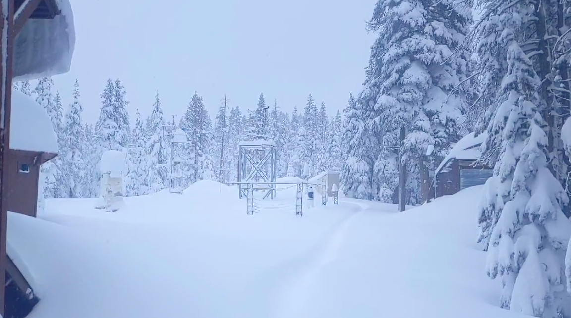
UC Berkeley Central Sierra Snow Lab. (Photo: cssl.berkeley.edu)
Reservoir, Snowpack Levels Continue To Rise Across California Due To ‘Bomb Cyclone’ Storms
Snowpack levels over 200%, as reservoirs reach the highest January levels not seen in years
By Evan Symon, January 11, 2023 2:30 am
The numerous “atmospheric river” rain storms that have pounded the state constantly since late December have continued to fill back in reservoirs and add to the snowpack across the state, with levels now going way above average for the usual amount in early-mid January.
Bomb cyclones have brought record rain and snow to the state, with over a dozen deaths and damage recorded from Redding to San Diego. Evacuations of entire communities has also occurred due to flood and mudslide worries in Santa Cruz and Santa Barbara Counties. However, on Tuesday, a silver lining to the storms began to shine brighter, as drought depleted reservoirs and underwhelmed snowpack in the mountains relied on to bring water continuously down in the hot summer months have both risen exponentially in the past few weeks. Last week, snow pack levels were at 174% where they usually at, with reservoirs quickly moving up from lower drought-withered levels. As the ground has saturated, and storms continue to deluge the state with rain, these numbers have only increased.
In Northern California, snowpack has increased to over 200% of normal levels, with reservoirs quickly climbing up. Don Pedro Reservoir is currently at 97% it’s normal January level, with Shasta coming in at 67%, New Melones at 59%, and Trinity at 42%, way above the state average at this time last year at 38%. In particular, Lake Oroville, which has been at record low levels for the past few years below 30% capacity, shot up to 38% capacity in only a matter of days. Currently the lake is now at 85% of where the normal level should be and climbing. The water level itself is currently at 748 feet, much higher than the level in 2021 at 690 feet. With the water level rising now between 607 feet per day, and rain in the forecast for at least the next week, many hope that the water level could get close to the full pool amount of 900 feet by the time of the critical snowpack level measuring date of April 1st.
In Southern California, while rain has not been as constant as in the North, the added water is also filling up reservoirs in the region. Outside of California, the added rain and snow could also help California with down stream water as well, with expected high Rocky Mountain snowpack levels possibly even giving the Colorado River and Lake Mead their highest level rises in over a decade.
The rises, and continued rain and snow, have led many water experts to remain cautiously optimistic in recent weeks. The general consensus is while there is still a drought, the storms have definitely been alleviating the situation, with further improvement possibly meaning a year without any drastic cuts.
“Outside of the floods and destruction, people here have been really glad to see this rain. They wish they got it more spaced out, but we really can’t control how we get it right now,” Jack Wesley, a water systems consultant for farms and multi-family homes, told the Globe on Tuesday. “We are seeing a lot more snow pack and higher reservoir levels. This time next week, we might be talking about 250% snowpack and reservoirs even higher. But lets just take this slowly. We’re doing better, but we need water continuously coming in, and with the drought, it’s easier said than done. Higher temps might also melt the snow pack early like it did the last several years so we have dry summer months, and cuts in allotments in SoCal could mean restrictions again too.”
“But, that being said, we are definitely on the right track. We are getting the water we need and we’re seeing improvements we could only have prayed for last year. We all just wish that us getting it wouldn’t have been so destructive.”
Rain is expected to continue throughout the state intermittently for at least the next week as another storm is due to hit the state in the coming days.


- Bill to Require Law Enforcement Disclosure if AI Was Used To Help Write Reports - August 7, 2025
- Gov. Newsom Files FOIA Request To ‘Expose True Cost’ Of L.A. Federal Troop Deployment for Anti-ICE Riots - August 6, 2025
- California Redistricting: How Newsom’s Plan Will Demolish Hard Fought GOP Gains - August 6, 2025
RELATED ARTICLES
-

-
-
 September 9, 2022
Last year, SoCal rainfall was within 90% of average. Currently, the snowpack is 200% of normal.
What’s the definition of “drought” again?
It pays politically to keep this thing alive as long as possible, then milk it to legislate more and more and more control over the people. Gavin is a case in point…and it sure is NOT about snow, water, etc.
Newsom could be up to his neck in flood water and he would scream drought. Drought is a state of mind and his mind is a shriveled old raisin.
I live in Oregon (on the California boarder) not in California, but I have wondered the same thing here. It seems any amount less than average they call a draught, but by definition of average that makes 1/2 of all years a draught. I am a math guy and in Statistics the basic rule is you have to be two standard deviations from the mean (average) to be considered unusual. That would mean that you would have to have less than 53% of the average precipitation before it would be considered unusual. To me that should be the definition of a draught. Of course that does not take into account accumulating years of low precipitation, so other calculations such as reservoir levels would also need to be accounted for.
Selling tickets now to watch all this water flow out to sea! Reserve your river bank spot now!
Maybe Newsom and Democrats in the legislature will decide to build more dams and reservoirs to capture all that water? Naw, why would they want to give up their power of water scarcity over California citizens? They’d rather fund abortions and transgender surgeries for anyone who stumbles into the state.
Agreed….our corrupt selfish greedy politicians need to be forced out of office….that’s why so many people have moved out of state…
It won’t matter if this corrupt state government continues to allow the absurd runoff to the ocean.
PDR, they just don’t care. If they did reservoirs and dams would have started being built fifty years ago.
Their corrupt selfish laws & decisions don’t affect them….so they care….we need to get rid of them, whatever it takes….
Currently the snow pack is 228% average (to date) for the state.
Bomb Cyclone is wording to induce fear and terror.
Let’s call this what it is, a big winter rainstorm that produces snow in higher elevations.
I am thankful for the rain but saddened to know it will not be captured for the future drought years. Shameful!
Agreed….
Quick! Let’s pass another bond measure to move dirt around for the delta smelt and not raise shasta dam or build the Sites reservoir and then blame the misspent funds on climate change.
607 feet a day is quite the inflow.
Flood control regulations set a top of conservancy level. This is a level which is used to reserve space for sudden snowmelt or additional heavy rains to lower flood risks downstream. Presently, this limit is around 850ft for Lake Oroville.
The lake is now above normal for this time of the year.
Due to the recent rains, Lake Oroville is higher than the “top of conservevation” the Department of Water Resources has been releasing water through the spillway. As of 4:00 PM on 17 March, the release rate is set at 32,500 cubic feet per second.